A couple years ago, my wife and I walked up to San Juan Hill (W6/CT-230) to activate this summit. It was a place I’ve been to many times on my mountain bike. The walk up took about an hour and a half, and of course and hour and half down. I remember thinking you know, this is nice and all, but I wonder what it would be like to ride up here and do this?
Fast forward to Saturday, February 4th, 2023 and here I am doing my first ever mountain bike ride for a summits on the air activation. It’s actually a twofer because it’s located within Chino Hills State Park (CHSP), a known Parks on the Air location (K-1139).
As an avid mountain biker, I know there are many ways to get to San Juan Hill, with varying degrees of mileage and steepness. I could have started in Carbon Canyon Regional Park, rode up to 4 corners and then up the easy Bovinian Delight single track for the final climb up. That would have been a more gradual ride, but I figured it would take longer. Check out that roughly 15 mile round trip course here: https://www.strava.com/routes/3056655116721739236
Another option was to drive into the park and start by the campground. That is the shortest route and steepest way up. It’s also the most expensive parking area ($10 inside CHSP vs. $5 at Carbon Canyon). Check out that roughly 5 mile round trip course here: https://www.strava.com/routes/3056653955878076900
Two other options I could try in the “free parking area” of Yorba Linda were the Casino Ridge route (map) and the South Ridge via Rimcrest route (map). Since I had done the Rimcrest to South Ridge route before on foot and ridden it many times in the past 20 years, I figured that was the best way to try this adventure. At least I knew what I was getting myself into. But did I really know?
Riding up a steep incline on a mountain bike is one thing, but riding up it with 25 pounds of gear is another thing entirely. Your first climb from the street with no warm up at all is about a 12% grade. Most vehicle bridges are about a 2-4% grade at most! The Rimcrest to South Ridge route has at least 5 steep sections like this on the way up. I found myself doing something I haven’t done in about 20 years riding mountain bikes: walking up the steep stuff. The entire trip up took me just as long on a mountain bike as it had on foot a couple years before. Strava called this ride up a “Massive Relative Effort”. (See stats: https://www.strava.com/activities/8505889840) But, I will say that the trip down was a lot more enjoyable. It took about 20 minutes via mountain bike vs. 90 minutes on foot. Worth it? Absolutely! One of the most satisfying benefits of mountain biking is the free roller coaster ride after a couple hours of hard work.
Now I’ll talk about the activation itself. I brought two radios: a Yaesu FT-70DR for 2 meters for local contacts (25-100 miles) and a QRP rig, the Recent RS-918 for medium range contacts (over 300 miles) which can do everything between 10 meters to 160 meters. I packed a Super Antenna MP1 with radials for 10-40 meters.
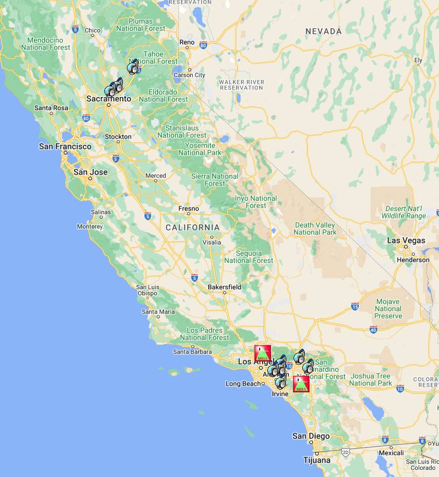
Oddly, I didn’t have cell data service up there. I say oddly because I was just a mile or two (as the crow flies) from Yorba Linda and I have Verizon. I wasn’t able to spot myself. Fortunately, one or two of my first contacts did the spotting for me and I was off making more contacts in no time on VHF (146.52) including a couple summit to summit contacts. For those new to this game, summit to summit contacts are like gold. That’s when another guy is doing exactly what you’re doing on another summit!
After a while I switched over to 20 meters and made a few more contacts – mostly northern California. You can see by my logs and the map of contacts that my time was certainly not wasted! I would say that the only thing I did wrong on this trip was not having a high gain antenna for the Yaesu FT-70. Next time I plan to bring my 13 foot collapsible fiberglass pole and a my N9TAX roll-up dual band j-pole. I’ve made 100 mile contacts with that setup before, most notably on my Catalina SOTA trip. And finally, my biggest lesson of the day is that next time, I’m taking the longer Carbon Canyon route!
As I mentioned, this was my first SOTA via MTB trip. I found a way to combine two things I love. Mountain biking challenges me physically and rewards me with the super fun gravity assisted experiences and some of the best views of the world around me. Ham radio is a hobby that challenges me mentally and has opened up a whole new world of social connections. To me it’s the perfect blend of physically challenging and mentally challenging experiences. And it opens up a whole new world of fun! If you’ve never tried it, I highly recommend it!
Contact Log
| W6/CT-230 | 20230204 | 1120 | 144Mhz | FM | KD6RAP | ROBERT - RIALTO | |
| W6/CT-230 | 20230204 | 1125 | 144Mhz | FM | KN6VJV | MARK - YORBA LINDA | |
| W6/CT-230 | 20230204 | 1130 | 144Mhz | FM | KK6DDC | MARK - IRVINE | |
| W6/CT-230 | 20230204 | 1135 | 144Mhz | FM | KN6FNY | W6/CT-268 | KEVIN - LAGUNA NIGUEL |
| W6/CT-230 | 20230204 | 1140 | 144Mhz | FM | K6KWV | KC - DIAMOND BAR | |
| W6/CT-230 | 20230204 | 1145 | 144Mhz | FM | N6UNH | DIRK - MORENO VALLEY | |
| W6/CT-230 | 20230204 | 1205 | 14.0Mhz | SSB | K6KWV | KC - DIAMOND BAR | |
| W6/CT-230 | 20230204 | 1210 | 14.0Mhz | SSB | K6SDW | EDWARD - CITRUS HEIGHTS | |
| W6/CT-230 | 20230204 | 1215 | 14.0Mhz | SSB | N6AN | W6/CT-225 | DAVID - PASADENA |
| W6/CT-230 | 20230204 | 1217 | 14.0Mhz | SSB | WB6POT | PETER - SAN JOSE | |
| W6/CT-230 | 20230204 | 1218 | 14.0Mhz | SSB | AD6QF | ROBERT K-1055 - FULLERTON | |
| W6/CT-230 | 20230204 | 1225 | 14.0Mhz | SSB | W6DT | WAYNE - MEADOW VISTA |